John Parry Lewis was commissioned to research and write a report on the future of Cambridge and sub-region in the 1970s. Despite its cost, it was ignored. But what was ignored, and can we learn anything from it?
UPDATE: I have digitised Part 1 of the plan by Prof Parry Lewis. You can read it here.
One of the things I find often missing from contemporary future visions of Cambridge are maps of where all of the extra housing and development is to go. This is one of the reasons why I find past maps interesting – if anything to find out how similar the plans were to how things turned out.
One of the books that got me interested in Cambridge’s past was The Cambridge That Never Was, by Francis Reeve. 
This unbuilt proposal by Gordon Logie, then the Cambridge City Architect for the City Council shows an alternative Lion Yard with large and small concert hall.
What Cambridge lost
The post-war era was one of huge change everywhere. Changes could have been even bigger in Cambridge if it were not for an active civic society including the Cambridge Preservation Society (now Cambridge Past, Present & Future) who successfully campaigned against a number of proposals that would have demolished swathes of historical Cambridge town in order to make way for wide roadways. By the time Cambridge got to the 1970s, many civic treasures had been lost.

Gone: The Cambridge Daily News and New Theatre (opposite Mandela House / The Old Police Station on Regent Street)

Gone – The Wesleyan Chapel – now an office block where HSBC and Strutt & Parker have offices on Hills Road
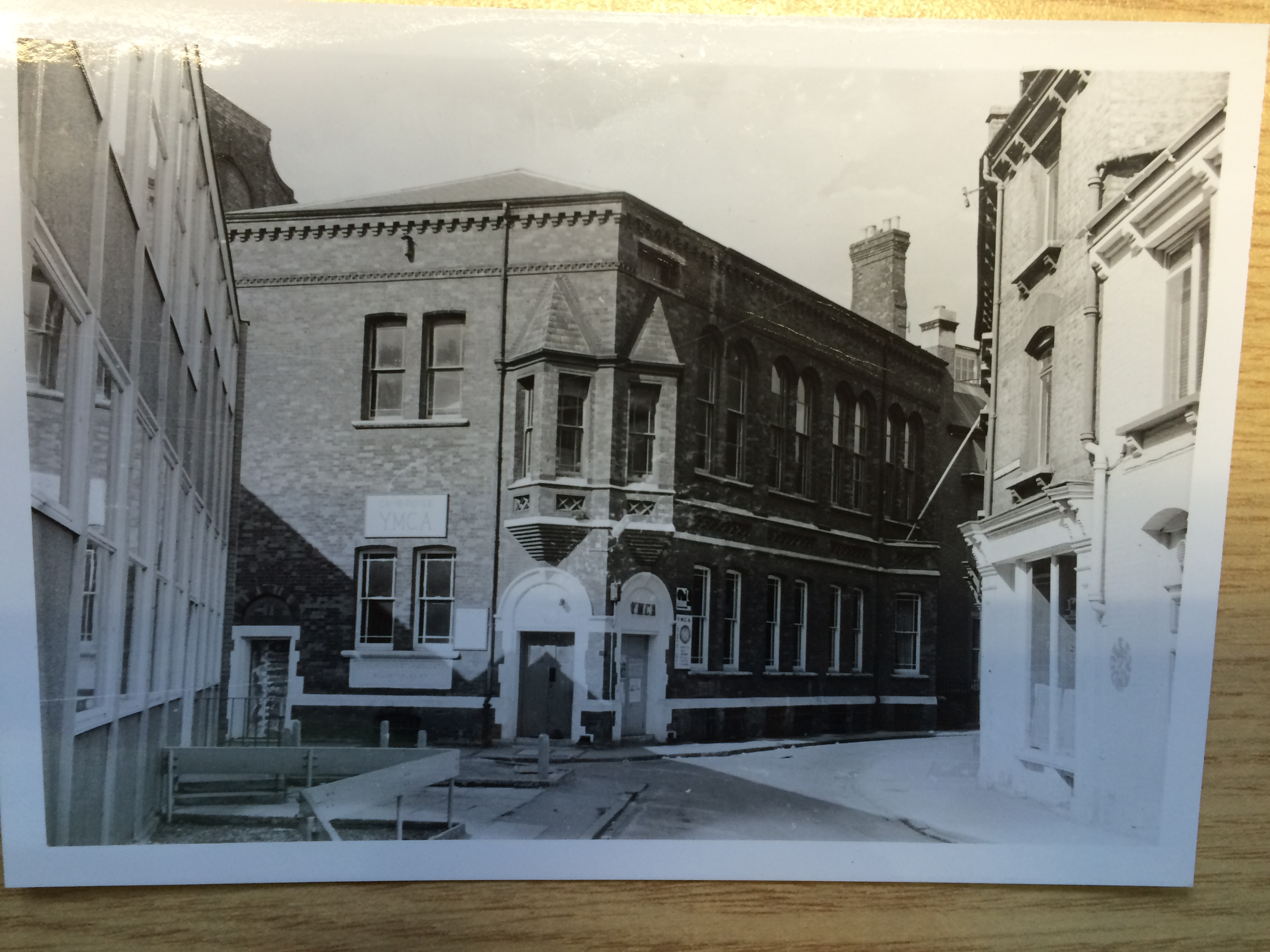
Gone – the old YMCA (including Alexandra Hall – which hosted many a gig and concert) now somewhere underneath the Lion Yard Shopping Centre

Gone – the old Playhouse Cinema on Mill Road

…with its heart torn out before its conversion first to Cambridge’s first supermarket, and until recently the charity shop Sally Anne’s.

Gone – the old Post Office opposite Lloyds on the corner of Petty Cury.
“So…you want those all rebuilt?”
Down to the last moss-covered roof tile.
Well…not quite. I’d just like to see more contemporary buildings very visibly taking inspiration from the nice things we used to have as well as some of the unbuilt designs of schemes that fell by the wayside.
“What did the 1970s have to say?”
They had lots of tables and datamapping – below is Parry’s bus frequency map.

John Parry Lewis’s map of the frequency of bus services into Cambridge from surrounding areas, circa 1975.
What would a similar map look like for today’s bus services into Cambridge? One for the Cambridge Area Bus Users or Smarter Cambridge Transport to pick up and run with?

The one piece of information we wouldn’t be able to get hold of today due to the privatisation of the buses in the mid-1980s are on which routes cover their costs. It would be designated as commercially sensitive information for the bus operators.
For trains, we get some indication of the ideas that Parry had regarding the expansion of Cambridge – namely that he concluded that the immediate town centre was becoming too big for the city and subregion, and that an alternative centre needed to be created.

Parry’s plans in the 1970s was for a new centre in Trumpington.
Plans were already advanced for the construction of the M11 motorway, although debate for a western bypass were already in future regional plans as long ago as the early 1930s when Davidge’s report on regional planning in Cambridgeshire was published in 1934. The Cambridge Northern Bypass would also be constructed to become part of the now much-maligned A14. This bypass was also completed in the 1970s.

Above – Parry’s plans for Cambridge in the 1970s – option of southward expansion.
The area around the N encircled in bold black is where Trumpington is. The phasing shows a significant expansion of Cambridge both south-westwards towards Melbourn and Royston, as well as south-easterly through Great Shelford and onto Sawston.
An Easterly expansion towards Fulbourn

Above – Parry’s plans for Cambridge in the 1970s – option of eastward expansion.

The snapshot above of Cambridge today (link here).
One of the things Cambridge residents who have lived in the city for decades – especially on the southern & eastern sides of the city, is how Cambridge Airport, Stourbridge Common (& the River Cam) and Coldhams Common have a somewhat isolating effect on Abbey Ward – the group of houses just to the left of the Cambridge Airport label on the map above. The proposal turns Teversham and the land north of Cherry Hinton (ironically being developed now) into an alternative centre in Cambridge that both links up with Abbey ward, then expands significantly eastward towards and beyond Fulbourn out to where the current A14 and A11 dual carriageways meet.
“Why didn’t we get it?”
I’ve not gotten that far into my research, but my hunch is that producing maps such as these would have been more than enough to raise opposition to the plans of Cambridge expanding too rapidly. This perhaps is reflected by the lack of maps on where very long term future growth should go.
Piecemeal development instead?
Peter Bryan’s excellent history of Cambridge’s expansion is well worth reading (a bargain from G.David in Cambridge ) covers this far better than I ever could.
 Cambridge – the shaping of the city
One of the things that piecemeal expansion of towns risks is that the essential civic infrastructure and public facilities are not built, or are under-provided. One of the things that Cambridge has lacked despite all of the plans and dreams is the public and civic infrastructure to match the population growth. When I started secondary school, the population of Cambridge City was just over 100,000. Today it is already over 125,000 – we’ve grown by the size of a town like Haverhill, or two Saffron Waldens. Have we had the level of facilities expanding to provide that? I fear we’ve gone in the opposite direction.
“How are these past studies useful?”
For many reasons, but for me they help me find out why past schemes fell or failed – thus informing questions about future plans. Furthermore, they also show the sort of data that needs collecting, collating and displaying to inform public debate.
Supporting my future research on the story of Cambridge the town
If you enjoyed this article and are interested in the history of Cambridge the town and the people who made our modern city, please support my research in bringing their records of achievement to wider audiences. Click here if you would like to make a donation or take out a small subscription to support my ongoing work.

