Summary
Have a look at the maps below:


From the British Newspaper Archive here (£Requires Subscription)
The text accompanying the maps states as follows:
PROPOSED TRAMWAY EXTENSION AT CAMBRIDGE.
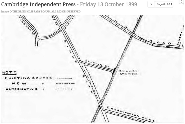
“Those who peruse our report of the meeting of Cambridge Town Council on Monday, will find additional interest therein first studying the above map. There they will see clearly outlined what is already done, and what it is suggested might be done. The thick dark lines leading from the old Post Office to the Station, and from East-road to Great St. Mary’s Church, show the existing tram lines.
The dot-and-dash lines show the extensions it is proposed to make. These are four in number. One leads by Emmanuel-street and Park-side to Mill-road and Romsey Town. Another continues the existing line from Station-road to the Rock Estate. third continues the East-road line to a point on Newmarket-road. Lastly, there is the proposed line to Chesterton, which is so arranged to tap the De Freville Estate and Old Chesterton generally.
The route proposed is by way of Emmanuel-street, Emmanuel-road, Victoria Avenue, and Chesterton-road, though to this an alternate itinerary is suggested, starting at Hobson-street, passing along King-street, and thence via Victoria Avenue to Chesterton. The Chesterton route is the part of the scheme most criticised.”
Cambridge got permission to build its first horse drawn tram network in 1879.

Above, from the British Newspaper Archive, and below, from the Museum of Cambridge.

The significance of the proposed extensions
The top map shows Chesterton. In 1899 Chesterton was outside the boundary of Cambridge Borough Council – strange to think of that today, but it was. This was 10 years after the completion of the Victoria Road Bridge – prior to that, the only thing that connected Chesterton with Cambridge were the small ferries. The proposed extension would have further strengthened the links between the two.
The middle map shows the proposal of taking the trams down Mill Road – something that would have required the widening of the road.
The lower map shows the proposal to extend the tram network over the railway bridge on Hills Road, to head down Cherry Hinton Road. The plan was to have a terminus at The Rock Pub, on the edge of the new housing estate known as ‘New Cherry Hinton’.
Proposals to electrify the network

In 1904 we had the first conversations at the council proposing electrifying the tram network, which led to some amusing satire…

The above postcard from the Museum of Cambridge.
But they struggled to deal with rising competition from the Ortona motor bus company, which as early as 1901 was causing nightmares for the directors.

The above – from the Cambridgeshire Collection in the Cambridge Central Library.
Bankrupcy and closure.

Despite pleas from campaigners heading down to the High Court to protest against the winding up of the tram company, and despite the sympathies of the judge on electrification, there was nothing in law to stop the winding up order from going through.

And thus the last horse drawn tram to trundle through Cambridge on a commercial basis did so until February 1914. Given how most of the motor buses were requisitioned on the outbreak of war, I wonder what would have happened if they had managed to keep on going until the outbreak of war – would the service have been municipalised to meet the demands of war?
